|
PREMESSA Castellavazzo
Ť un paese che presenta un
passato molto interessante, fin dalla sue origini preromane. Con líavvento
di Roma Ť diventando punto di
riferimento per tutta la Valbelluna. In
tempi recenti Castellavazzo si distinse per líarte di ďcavŗr e laorŗr
la pieraĒ, grazie ai suoi scalpellini o tagliapietre, che lavorarono nelle piý distanti localitŗ
del mondo, facendo conoscere la Pietra di Castellavazzo, materiale
tutt'ora estremamente pregiato. Forse per le stesse cause che svilupparono líattivitŗ di estrazione e lavorazione della pietra, in Castellavazzo venne realizzato uno stabilimento per la produzione di cementi per l'edilizia. Questo ha havuto una notevole importanza, anche nella costruzione delle dighe e delle gallerie per le centrali elettriche, la piý famosa delle quali Ť quella del Vajont. |
|||
|
LA
STORIA IN GRANDI LINEE Il
primo complesso industriale per la produzione di cemento in
Castellavazzo venne costruito dalla Ditta ďColomboĒ (data?). Essa
perÚ fallž rapidamente perchť produceva un cemento inadatto alle costruzioni. La
cementeria fu poi rilevata dallíUnione Cementi Marchino di Casale
Monferrato (data?). Allíinizio la produzione Ť controllata dalla Societŗ Adriatica, la quale impiega il prodotto in tutti i cantieri del Bellunese con risultati soddisfacenti e sospende i controlli sul prodotto, considerandolo sicuro. Nella prima fase cíŤ un solo forno attivo, un ďMannstaedĒ a griglia rotante ed uno in riparazione. L'invio del materiale ai frantoi, posti allíinizio della catena di lavorazione, avveniva usando un complesso sistema composto da teleferiche, strade camionabili e ferrovie a scartamento ridotto di 600mm. Nei primi tempi, la fabbrica impiegava circa 250 operai, circa 40 erano donne che lavoravano sia all'estrazione sia al insaccamento. La
produzione divenne di 200t al giorno con produzione di: cemento di altoforno,
pozzolanico, ferrino e pozzolanico per dighe. La diga sul MaŤ a Pontesei, in valle Zoldana,
venne costruita con il
cemento dello stabilimento. La fornitura di cemento alla SADE, per la diga del Vajont,
venne rifiutata per non rinunciare ad altre forniture per altre ditte del Veneto.
Quindi lo stabilimento fornž solo il cemento per le
opere ausiliarie. La
centrale idroelettrica di Soverzene, invece, fu rivestita con questo cemento. Nel
tempo la cementeria si Ť molto automatizzata al punto che il
personale venne ridotto a sole 85 addetti, era presente un laboratorio di analisi dei materiali,
diretto da un chimico laureato. La
societŗ Marchino avrebbe voluto costruire a Dogna, sulla sinistra
del Piave, un nuovo stabilimento da 400t al giorno, ma il disastro del
Vajont ha
distrutto líarea e bloccato il progetto |
|||
|
|||
|
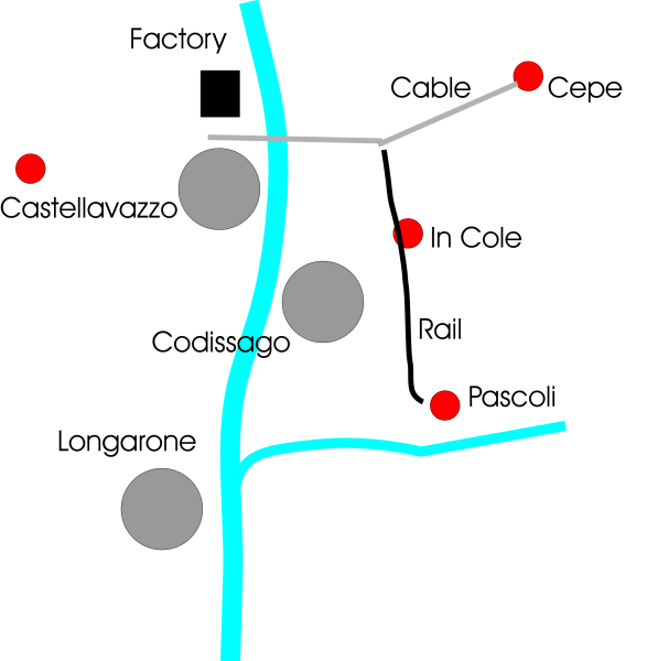
"Cepe" quarry
Is the oldest of this system, is placed at 1000m over the mountain in the left side of Piave river. It was exercised as a underground mine with much tunnels. The production was pozzolana extraction. A cableway was used to transport the ore just to the factory. |
Cava ďCepeĒ Il
piý antico, si trova a oltre 1000 m
slm e ha visto utilizzato un metodo di coltivazione da poter essere definita una miniera. |
||
|
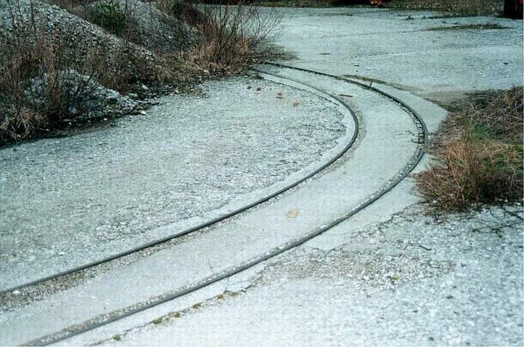
"In Cole" Quary This was the second extracion quarry, is located ove Codissago village. It was linket to the down station of the "Cepe" quarry, cableway over the Piave river, by a narrow gauge line, 600mm circa 1Km long. This was exercised early by human power and after by a Diesel loco. The railroad line was the same of the "Pascoli" quarry. |
Cava ďIn coleĒ Il
secondo luogo di estrazione Ť posto in linea con l'abitato di
Castellavazzo, a monte della frazione di Codissago, e era collegata alla stazione della funivia tramite
una linea a scartamento ridotto lunga circa 1 km, con l'impiego di locomotive Diesel.
La linea ferroviaria era la stessa della cava "Pascoli". |
||
|
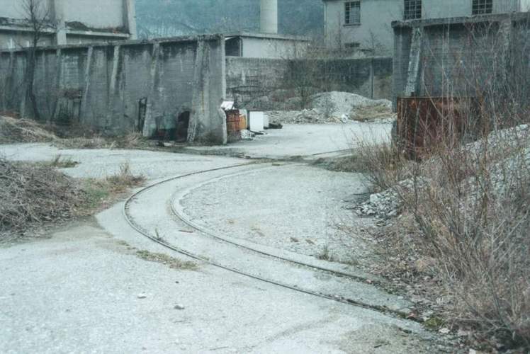
"Pascoli"quary In the early yearswere the men to push the ore cars: the line was dismounting. After, wher arrived a Diesel loco the trains were composed by 10-12 cars. They download the material in to the cableway. Some old men remember a steam loco, but probably was a Diesel that produced much smoke. Here there was marl extraction. |
Cava ďPascoliĒ Nei primi anni di esercizio i carrelli venivano spinti a mano, poi la linea fu dotata di una locomotiva che alcuni mi dicono a vapore mentre alcuni mi assicurano fosse a gasolio. Quest'ultimi mi fanno presente che fumava molto. Con la locomotiva venivano creati convogli di 10-12 carri che poi venivano scaricati nell'impianto della funivia. Qui veniva estratta la Marna. |
||
|
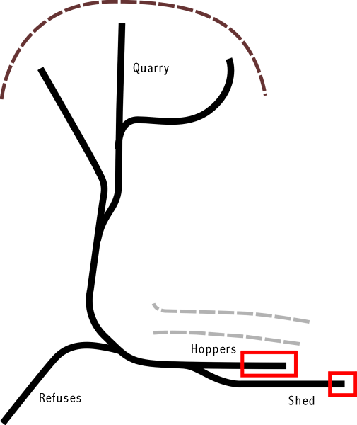
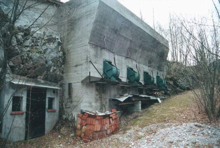
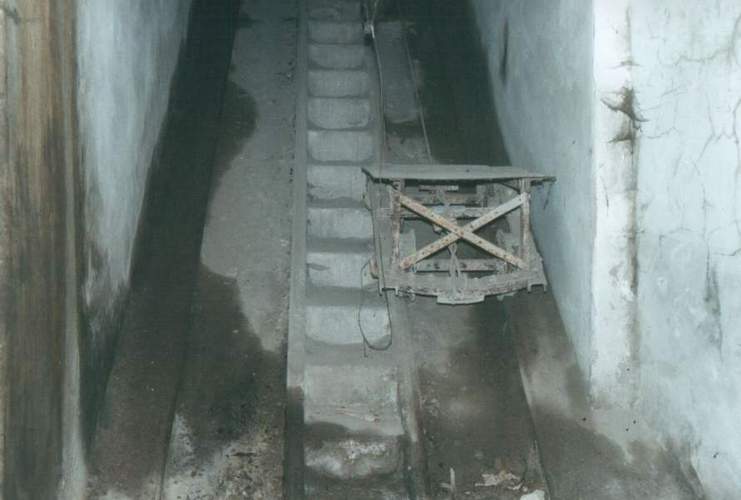
In the righ side of Piave rivers ther's only one limestone quarry. Here there were 3 traks to load the ore, 1 over the hoppers to discharg it on the road truck, 1 for the shed and 1 to discharger the refuses. Here was used some cars, a rail dumper, to charge the cars, and Diesel loco too.
|
Sul
lato destro c'Ť una sola cava per l'estrazione del calcare.
|
||